A weather radar is designed to monitor precipitation, calculate its phase, amount and speed of movement, and make very short-term forecasts. Radar is an indispensable tool in the operational work of weather forecasters. This page shows the combined precipitation intensity product of two weather radars located in Laukuva and Trakai Voke.
How does weather radar work?
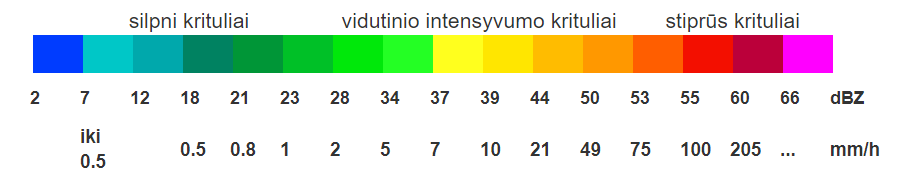
Radar detects precipitation in the following way: the transmitter sends out a concentrated electromagnetic beam and the receiver receives the energy, which is returned (“reflected”) from any object “encountered” in the path of the beam. The energy (reflectivity) intensity is processed and mapped in special dBZ units and can be interpreted as an approximate rainfall intensity (mm/h). The greater the strength of the reflected energy, the more intense the precipitation.
Weather radar data can be interpreted as more than just rainfall intensity. Ground-based observations at meteorological stations confirm that during the summer, heavy rain can be accompanied by thunderstorms at extremely high reflectivity values (>45 dBZ) and hailstorms are likely at around 50-55 dBZ. In winter, such high values are not achievable due to the prevailing air masses and the physical properties of snow. For example, at freezing temperatures, the radar will show moderate precipitation, but snow will often be heavy.
The main limitation of radar is that, due to the curvature of the Earth, information is gathered from higher and higher layers of the atmosphere as you move away from radar. In winter, precipitation usually forms in low clouds, so the radar beam sometimes “misses” light snow or drizzle. In addition to the curvature of the earth, there are other factors that affect the quality of radar data. When a hot and humid tropical air mass prevails in summer, the radar’s high sensitivity allows it to “catch” the moisture in the air and report it as light precipitation. Also, ground-based interference in the vicinity of radars (communication lines and towers, wind turbines, etc.) in some cases prevents the rainfall intensity from being recorded properly. Data discrepancies are quite rare, occurring a few days a year.
Radar as a tool to determine the actual situation and does not provide a forecast for the future It is up to the user to interpret the data and decide in which direction and how fast the precipitation area is moving, and how long it will take to reach a particular location. The radar data provided on this website can only be used as an auxiliary tool.